Thank you for your patience while we retrieve your images.
Aerial Photographs
▼
Aerial Photographs
▼
Maryland - Anne Arundel
Maryland - Baltimore City & Inner Harbor
Maryland - Port of Baltimore Harbor
Maryland -Baltimore County
Maryland -Calvert County
Maryland- Caroline County
Maryland - Carroll County
Maryland- Cecil County
Maryland - Charles County
Maryland -Dorchester
Maryland -Harford County
Maryland - Howard County
Maryland- Kent County
Maryland - Montgomery Cou
Maryland - PG County
Maryland -Queen Anne's
Maryland - Somerset Count
Maryland - St. Mary's Cou
Maryland -Talbot County
Maryland - Washington Cou
Maryland- Wicomico County
Maryland - Worchester Cou
Lower Delmarva Peninsula
Chesapeake Bay
Chesapeake Wildlife
Hunter's Favorites
Environmental Concerns
Farming on the Shore
Bay From Above Pairs
Shoreline Shapes and Monsters of the Chesapeake
Special Events in MD
Accident & Fire Investiga
Air to Air
New York City
South Florida
Bruce Long Gallery
Aerial / Flying Videos
▼
Aerial / Flying Videos
▼
All Stock
Nanticoke River
Oxford
Mid-Shore
Upper Shore
Special Productions
Hunter's Hangar ESN
Flying Video
Easton Airport Day Over the Years
Poplar Island
Non Flying Video / Images
▼
Non Flying Video / Images
▼
Bay From Above Then and N
Bud Blimp beer delivery
Christmas in St. Michaels
Easton Airport Day
Heading Out Town Creek
Hunter's Hangar ESN
OCC Model Boat Show 2018
Heading Out Town Creek 20
Poplar Island 2012 Visit
Red Hook new tug Launch
Recently Added
Social Media
▼
Social Media
▼
Website
Kickstarter
Facebook
Twitter
Google+
Contact
Blog
Home
»
Aloft Galleries
»
Photographs
»
Chesapeake Bay Views
»
Chesapeake Bay Shorelines Stock RTP
Taken
24-Sep-13
Visitors
25
57
of
62
photos
Thumbnails
Info
Categories & Keywords
Category:
Subcategory:
Subcategory Detail:
Keywords:
Aerial Photography
,
Chesapeake Bay
,
East Fork Wye River
,
Eastern Bay
,
Farm Land
,
Maryland
,
Queen Anne's County, Md
,
Shaw Bay
,
West Fork Wye River
,
Wye Island
,
Wye River
,
© Aloft Stock
Photo Info
Dimensions
5479 x 3551
Original file size
55.7 MB
Image type
TIFF
Color space
Adobe RGB (1998)
Date taken
25-Sep-13 06:44
Date modified
4-Oct-15 17:40
Shooting Conditions
Camera make
Canon
Camera model
Canon EOS 5D Mark II
Focal length
24 mm
Max lens aperture
f/4
Exposure
1/100 at f/7.1
Flash
Not fired, compulsory mode
Exposure bias
0 EV
Exposure mode
Auto
Exposure prog.
Normal
ISO speed
ISO 100
Metering mode
Pattern
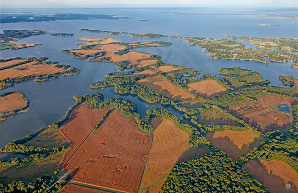
Wye Island in Queen Anne's County
Wye Island with the meeting of the East and West Forks of the Wye River. In the left middleground you can see Shaw Bay and in the background is the Eastern Bay. © Aloft Stock
No, you can not copy or use this image without written permission from the legal owner who is Aloft