Thank you for your patience while we retrieve your images.
Taken 26-Apr-05
Visitors 19


6 of 7 photos
Thumbnails
Info
Categories & Keywords

Category:Travel and Places
Subcategory:North America
Subcategory Detail:United States of America
Keywords:Aerial Photography, Chesapeake, Chesapeake Bay, Delmarva, Island Restoration, Maryland, Poplar Island, Talbot County, U.S. Army Corps of Engineers, © Aloft Stock
Photo Info

Dimensions3957 x 2471
Original file size28 MB
Image typeTIFF
Color spacesRGB
Date taken26-Apr-05 13:00
Date modified5-Oct-15 10:44
Shooting Conditions

Camera makeCanon
Camera modelCanon EOS-1DS
Focal length33 mm
Max lens aperturef/3.5
Exposure1/500 at f/9
FlashNot fired
Exposure bias0 EV
Exposure modeAuto
Exposure prog.Shutter priority
ISO speedISO 200
Metering modePattern
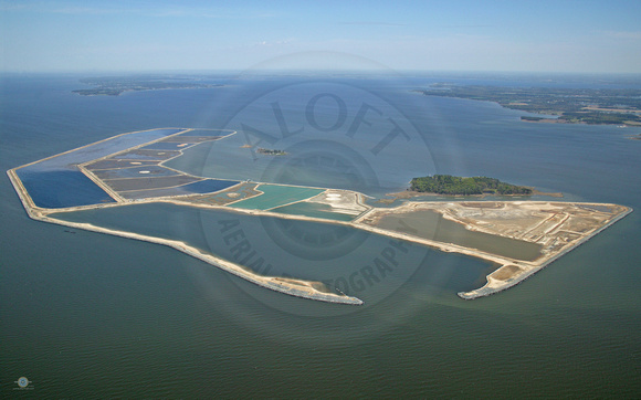
Poplar Island in 2005

Poplar Island in 2005

Poplar Island in 2005.

Federal and state officials selected Poplar Island in the 1990s as a dumping site for material dredged from the shipping channels approaching Baltimore (dredge soil from Baltimore Harbor is polluted and is not being used in Poplar Island). This would allow restoration of the island while keeping the Chesapeake's deep-draft shipping channels open, maintaining Baltimore as a major port, and halting the earlier practice of open-water dumping. The U.S. Army Corps of Engineers began reconstruction of the island in 1998 with the erection of dikes to contain the dredged material.
© Aloft Stock