Visitors 47
14 photos, 2 videos
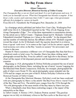
The Bay From Above, 75 Years of Change
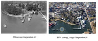
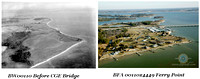
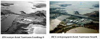
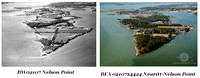
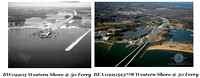
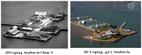
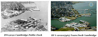
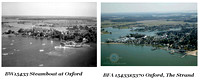
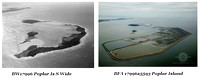
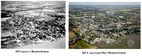
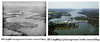
How much has the Chesapeake Bay changed over the past 75 years? "The Bay From Above: Aerial Views of the Bay Then and Now" juxtaposes the 1930s-1950s aerial photography of H. Robins Hollyday with new aerial photography by Hunter H. Harris, pairing views of various creeks, rivers and waterfront towns of the Bay region. The result is a visually arresting exhibition, one that should appeal to both watershed residents and visitors.
"The Bay From Above" was created from a partnership between Chesapeake Bay Maritime Museum and Harris's Aloft Aerial Photography, in cooperation with the Historical Society of Talbot County, whose collection includes Hollyday's photographs. The creation of this exhibit was supported by the Maryland Historical Trust, the National Park Service, and Verizon.
Hollyday worked as a commercial photographer from the 1930s to the 1950s, documenting life in Talbot County and on the Eastern Shore. Harris owns and operates his studio in Easton, where his own work focuses on land use and development. Contrasting Hollyday's black-and-white photographs with Harris's color images of spectacular vistas and the unique viewpoint hundreds of feet above the Bay, this exhibition provides astoundingly beautiful and startling evidence of the changes in the Chesapeake's shoreline, farmland, and Bay spaces over the last 75 years.
Here are several sample 'pairs' also below this stack of images, two video productions for you to enjoy!
Category:
Subcategory:
Subcategory Detail:
Keywords:Aerial, Aerial Photography, Bay, Chesapeake, Chesapeake Bay, Maryland, Photography
©Aloft Aerial Photography